A collaboration between two of Australia’s premier ag tech organisations, AxisTech and Spatial Hub Analytics, will advance the way farmers approach farm infrastructure mapping, providing them with opportunities for growth and insight.
Uniting excellence for farmer prosperity
Hailing from Western Australia and South Australia respectively, AxisTech and Spatial Hub Analytics have joined forces to elevate their technological offerings and extend the reach of their innovative data and software solutions.
Through this partnership, AxisTech and Spatial Hub Analytics are committed to providing their clients and partners with the tools and insights needed to successfully navigate the complexities of digital agriculture.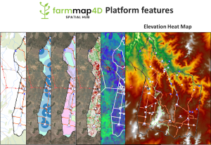
Harnessing the power of spatial intelligence
As one of the nation’s premier farm infrastructure mapping tools, FarmMap4D from Spatial Hub Analytics brings an array of cutting-edge features to the table:
- Comprehensive digital mapping: Map your entire farm infrastructure, gaining a holistic view of your land.
- Infrastructure mapping: Mapping of fences, water pipelines, connectivity and other infrastructure taking into account location, terrain, and distances.
- Stock management: Analyse water distances and assess carrying capacity efficiently for optimised livestock management.
- Advanced satellite analysis: Access high-resolution time series satellite data, ground cover analysis, NDVI, and agronomic insights for up-to-date land condition information.
Seamless integration for enhanced data insights
Spatial Hub Analytics partners and clients will gain access to AxisTech’s suite of IoT sensors, devices, cameras and WiFI, and data management solutions, enabling them to fulfil key requirements in digital agriculture.
As part of the ongoing partnership, FarmMap4D will be integrated into AxisTech’s innovative AxisStream data management platform, designed to centralise diverse datasets into a farmer or business-owned data store.
Farm maps will also become available through the AxisStream field app, empowering users to streamline their data collection, storage and analysis.
Legacy of Accomplishment
With more than 1200 livestock properties mapped across more than one million square kilometres, FarmMap4D covers an expansive 14 per cent of Australia’s landmass – equivalent to the size of Germany, twice over.
A diverse clientele, including major corporations like Harvest Road and Newmont, indigenous land groups, and individual pastoralists, attests to the widespread utility and value of this exceptional tool.
Joining Forces for a Thriving Future
The partnership between AxisTech and Spatial Hub Analytics is an exciting moment in the ag tech landscape.
By combining our strengths, we are dedicated to providing farmers with the tools they need to successfully navigate the complexities of modern agriculture.